Thursday, May 8, 2025

Mount Diablo Beacon


For millennia, humans have dreamed of flight. From ancient myths like Daedalus and Icarus to the designs of Leonardo Da Vinci, to Superman, humans have always wanted to fly like a bird. Almost every culture has stories of human flight. With the first human flight in a balloon by Etienne Montgolfier on October 15, 1783, the dream of human flight was realized, if not exactly like a bird. As early as 559 CE, attempts had been made at heavier than air flight, using a variety of kites, wings, and gliders, most with varying degrees of failure. The first manned glider flight was in 1853, and Otto Lilienthal made the first controlled glider flight in 1891. Lighter than air flight progressed, with the invention of the blimp in 1852 and the zeppelin in 1900, but heavier than air, powered, controlled flight remained elusive. It wasn’t until the Wright Brothers’ flight on December 17, 1903 that powered, controlled, heavier than air flight was achieved.

With the Wright Brothers’ success came an aviation explosion. Militaries around the world were interested in the new-dangled hydroplanes. Balloons had been used in military roles as early 1794 and by the American Civil War, had come into regular use as observation platforms. Balloons had two distinct disadvantages however, they were large and to be effective observation posts, they were tethered in place, making them rather conspicuous targets for the enemy. Airplanes suffered from neither of these drawbacks, they were small, fast, and maneuverable; making them perfect for reconnaissance missions. The US Army purchased a one of a kind Wright Model A for the Signal Corps in 1909, marking the beginning of military aviation. In 1909, the French Air Force was established. In 1910, the Imperial German Army established the Imperial German Flying Service. In 1911, the US Navy purchased it’s first plane, the Italian Air Force was founded, as was the Imperial Russian Air Service. In 1912 the Royal Flying Corps was founded.

This was the era of “Those Magnificent Men and their Flying Machines”. Competitions were held beginning in 1909 and many early speed and endurance records were made. There was growing fascination with these flying machines and those who flew them. The first Aeronautical Competition in the United States was held in Los Angeles in 1910. A year later, the Italians sent the airplane to war in the Italio-Turkish War of 1911, where they use airplanes for reconnaissance and bombing missions. It wouldn’t be long before airplanes became a staple of warfare.

In 1914, the assassination of Archduke Franz Ferdinand, heir to the Austro-Hungarian Empire, plunged the Europe into World War 1. This was when aerial combat came into its own and armed fighter aircraft, bombers, and reconnaissance aircraft were developed. The term “ace” was introduced for the first time, by the French to describe a pilot who had five or more victories, Certain planes became legendary, the Fokker DIII, the Albatross, the Sopwith Camel, the Fokker DR 1, and the Nieuport 17. This is when pilots became famous, Manfred von Richthofen, Max Immelmann, Ernst Udet, Eddie Rickenbacker, Rene Fonck, Werner Voss, and a young pilot named Hermann Goering.

When the war ended, many of the pilots who survived went on to help develop faster and safer planes. Air shows and competitions became popular and the airplane once more captured the public’s attention; particularly in the United States. In 1919 the US Navy Seaplane NC-4 completed the first trans-Atlantic flight from Long Island to Lisbon. As early as 1911, the US Postal Department experimented with using airplanes to transport mail and on May 15, 1918, the US Airmail Service was established. The creation of the airmail service accomplished two goals, the faster and more efficient transport of the mail and the expansion of civil aviation which, in turn, led to the training of new pilots.

There was a problem, due to the lack of aeronautical aids to navigation, especially those suited for night flying, airmail was placed on trains at night, adding valuable time to it’s delivery. A solution was at hand, in 1923, Congress authorized the Transcontinental Airway System, a series of concrete landmarks, beacons and emergency airfields that would stretch from coast to coast. By 1925, the airway extended from New York to San Francisco and by 1933 the airway was complete covering 18,000 miles and consisting of 1,500 beacons. This “highway in the sky” reduced the delivery time of transcontinental mail to be reduced by two business days.

In 1928, Standard Oil built five aviation beacons on the west coast as part of the system. They were located in Seattle, Portland, Mount Diablo, Los Angeles, and San Diego. The Mt. Diablo beacon is the only one still remaining and functional. The signal to light the beacons was given by Charles Lindbergh on April 15, 1928. Originally atop of a 75 foot steel tower, the light was moved to the top of the summit building by the Civilian Conservation Corps in April of 1941. The Mt. Diablo beacon could be seen for 150 miles and was one of the terminal beacons for the Transcontinental Airway. The beacon remained in service until December 8, 1941, when it was extinguished as precaution against a possible Japanese attack. It remained extinguished until December 7, 1964 when Fleet Admiral Chester Nimitz attended a memorial relighting ceremony to honor those who lost their lives at Pearl Harbor. He suggested the beacon be lit every December 7th as a memorial. Since then it has been lit, every December 7th as a memorial to those who lost their lives on that terrible day. Beginning in 2022, it is also lit on Memorial Day and Veteran’s Day. By 1973, the Transcontinental Airway System was obsolete and it was dismantled. While many of the concrete arrow landmarks still survive, the beacon on Mt. Diablo is one of the few surviving operational relics of the beginning of commercial aviation routes.

Thursday, February 6, 2025

Crocker Art Museum

In the heart of Sacramento, just a few blocks away from Old Town, the California State Railroad Museum, and the State Capitol there is a Victorian, Italianate mansion, which houses an invaluable treasure. It is the Crocker Art Museum, the oldest art museum in the Western United States, and one of the premier art museums in the country. The Crocker may be overshadowed by the art museums in San Francisco and Los Angeles, but that does not mean that it isn’t worth a visit. 

The mansion that is the original part of the Crocker Museum was built in 1853 by banker Benjamin Franklin Hastings and purchased in 1868 by Edwin B. Crocker, former California Supreme Court Justice, lawyer and elder brother of Charles Crocker, of Central Pacific Railroad fame. Born in 1818 in New York, by the 1840’s Edwin was practicing law in Indiana and was a former member of the Liberty Party and an abolitionist. He was selected as a delegate from Indiana to the Free Soil Party convention. He and his wife moved to California in 1852, and he chaired the first meeting of the California Republican Party in 1856. He was appointed an Associate Justice of the California Supreme Court in 1863 by Governor Leland Stanford and stepped down in 1864 after Justices were elected. In 1865, he became counsel to the Central Pacific Railroad of which his younger brother Charles and Stanford were owners along with Collis Huntington and Mark Hopkins. He was the Central Pacific’s legal counsel while the Transcontinental Railroad was being built. 

A month after the driving of the Golden Spike at Promontory Point, Utah in May of 1869, EB Crocker suffered a stroke and retired from his legal practice. With his legal practice at an end, Crocker, his wife Margaret, and his family traveled Europe and began collecting art. After two years, the Crockers returned home with over 700 paintings and 1344 drawings. In 1871, Crocker commissioned Seth Babson, architect of the Stanford Mansion, to design a building to house his art collection. The gallery building was completed in 1874, and originally contained a bowling alley, skating rink, grand ball room, a natural history museum, and a library. At the time, Crocker’s collection was the largest private collection in the United States and held more paintings than the Metropolitan Museum of Art. 

Edwin Crocker died of complications from his stroke in 1875 and left the gallery and mansion to his wife and daughters. The gallery became a social hub in Sacramento and Mrs. Crocker hosted many luminaries of the era including Queen Lili’uokalani, President Ulysses Grant, and Oscar Wilde. In 1885, the gallery was given to the City of Sacramento and the California Museum Association to be held in public trust.

The Crocker Art Museum underwent an expansion in 2010 with the addition of the Teel Family Pavilion. Today, the museum not only holds an extensive collection of European art, but also extensive collections of California, Asian, and art from Oceania, as well as as a ceramics collection ranging from the Neolithic to the modern. Of special note are The Fandango and Sunday Morning at the Mines by Charles Christian Nahl as well as works depicting California by Thomas Hill, Edward Deakin and Albert Bierstadt. Notable among the European works are several portraits and religious paintings by Dutch and Flemish masters such as Pieter Brueghel the Younger.. 

The museum located at 216 O Street in Sacramento and is open from 10:00 am to 5:00 pm, Wednesday through Sunday and 10:00 am to 9:00 pm on Thursdays. Tickets are $15.00 for adults, $10.00 for college students, seniors and the military, $8.00 for youth ages 6-17, and free for those 6 and under. For more information about the museum and special events please visit the museum’s website at: https://www.crockerart.org/ 

GETTING THERE: From 414 Mason Street. Get on Interstate 80 East from 5th Street. Continue on I-80 East to US 50 toward Sacramento/South Lake Tahoe/Capital City Freeway. Take Exit 3 to Downtown Sacramento/Jefferson Blvd. Keep left onto CA-275/Calbadon Parkway. Turn right onto 3rd Street and then turn left onto O Street.

Sunday, December 22, 2024

Oakland Aviation Museum


Oakland is often seen as the awkward step-sister of San Francisco. Despite being the home of Jack London, Gertrude Stein, who famously remarked of Oakland, “There is no there, there”, Robert Lewis Stevenson, Joaquin Miller, Henry J. Kaiser, Bernard Maybeck, Buster Crabbe, Frank Oz, Bruce Lee, and many other famous (and infamous) people, Oakland never had the fame and adoration showered upon San Francisco. Yet, Oakland has some firsts which it can call its own. The Popsicle was invented by Oakland native Frank Epperson, Victor Bergeron claimed to have invented the Mai Tai at his Oakland bar and restaurant, and Children’s Fairyland, opened in 1950 was one of the inspirations for Disneyland. Despite having a rich history of its own, including being the terminus for the Transcontinental Railroad, even during the 1906 Earthquake, San Franciscans toasted their survival with the phrase, “Eat, Drink, and Be Merry, for tomorrow we may have to live in Oakland.”


Oakland was an early hub for aviation. Oakland Airport was constructed and opened in 1927, with a 7,020 foot long runway, the longest in the world at the time. Originally constructed for the Dole Air Race from California to Hawaii, Oakland Airport became the starting point for the first Trans-Pacific flight to Hawaii by the Bird of Paradise on June 28–29, 1927, and was officially dedicated on September 17, 1927 by Charles Lindbergh. Hegenberger Road in Oakland is named after Major General Albert F. Hegenberger, who along with Brigadier General Lester J. Maitland, for whom Maitland Drive is named, made the flight to Hawaii in the Bird of Paradise. In December, the Boeing Air Transport, the predecessor to United Airlines, made Oakland Airport its west coast home.


By December of 1929, construction of Oakland Airport was complete with a terminal, five hangars, a restaurant, and America’s first airport inn. The long runway and amenities made it a hub for long distance flight. The first flight from North America to Australia took off from Oakland on May 31, 1928, and Amelia Earhart’s solo flight from Hawaii in 1935 ended here on on January 12. Her ill fated second attempt to circumnavigate the globe took off from Oakland on May 21, 1937. One off attempts were not the only long haul flights to originate or terminate in Oakland. In the 30’s up until the beginning of World War II both Boeing and Trans World Airlines operated out of Oakland.


With the beginning of World War II, Oakland Airport became a major logistics hub for the West Coast. Proximity to the port facilities and railroads meant that a huge amount of men and materiel were sent out of Oakland. In 1943, Oakland Airport became Naval Air Station Oakland and all of the commercial flights were transferred to Mills Field (San Francisco Airport). At the end of the war, Oakland became a reserve air field and passenger service slowly returned. By 1962, a new airport terminal was opened with a 10,000 foot runway to accommodate commercial jet aircraft and the original Oakland Airport became known as North Field and now acts as an air freight, charter, and general aviation hub.


Housed in the hanger that once was the location of the Boeing School of Aeronautics, is the Oakland Aviation Museum. While not as well known as other Bay Area attractions, it offers a look at a nearly forgotten part of Bay Area and California history. Obviously, its focus is on the history of aviation in Oakland and Alameda, but that is not the sole focus of the museum. The museum contains exhibits about Amelia Earhart, Women in Aviation, the US 8th Air Force, Naval Aviation, and African Americans in Aviation. There are exhibits on World Airways, Transocean Air Lines and Trans International, later Transamerica Airlines; all three of which operated scheduled and charter service out of Oakland.


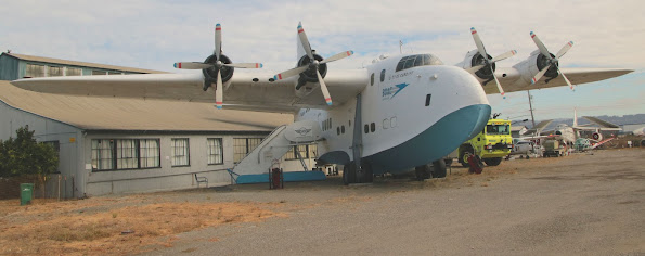
Beyond those exhibits, the museum also has an interesting collection of over 30 aircraft ranging from a replica of a Wright EX to a Harrier that was used by NASA. Included in the collection are a ¾ scale P-51 Mustang, a MIG-15, an A-6 Intruder, an F-14 Tomcat, and an ADM 20 “Quail” cruise missile. The highlight of the collection is the museum’s Short Solent Flying Boat, one of only two left in existence. This Solent, named the City of Cardiff and now in BOAC livery, made an appearance in Raiders of the Lost Ark and was once owned by Howard Hughes. The museum also has a collection of light aircraft and gliders and several aircraft engines on static display. There are tours of the Solent and “open cockpit” days during which the public can get a much closer look at the aircraft on display. The museum is located at 8252 Earhart Road, Oakland. For more information including hours of operation, admission fees, and a schedule of special events, please visit the museum’s website at: https://www.oaklandaviationmuseum.org.


GETTING THERE: From 414 Mason Street: Head south on Mason St toward Derby St. Use the right lane to turn left onto Eddy St. Use the right 2 lanes to turn right onto 5th Street. Continue onto 5th St.Use the left 2 lanes to turn sharply left to merge onto I-80 E. Continue on I-80 E. Take I-880 S to Hegenberger Rd in Oakland. Take exit 36 from I-880 S. Use the right lane to take exit 36 for Hegenberger Rd toward Coliseum/Oakland Arpt. Follow Hegenberger Rd, CA-61 N/Doolittle Dr and Earhart Rd to Boeing St. Use the right 2 lanes to turn right onto Hegenberger Rd. Turn right onto CA-61 N/Doolittle Dr. Use the 2nd from the left lane to turn left onto Swan Way. Turn right onto Earhart Rd. Turn right onto Cooke St. Turn left onto Boeing St.  The museum will be on the right.


Oakland Aviation Museum
8252 Earhart Rd, Oakland, CA 94621

Monday, July 15, 2024

La Purisima State Historic Park


Situated near the city of Lompoc sits the most completely restored of California’s twenty one missions, Mission La Purisima Concepcion de Maria Santisma. The eleventh of the missions, founded on December 8, 1787 by Father Fermin de Lasuen, the feast day of the Immaculate Conception in the liturgical calendar of the Catholic Church. The mission was one of three, along with San Buenaventura and Santa Barbara which were built to link the missions in the south to those farther north, to solidify the Spanish presence along the Santa Barbara Channel, and to keep the indigenous tribes in the area under Spanish control.

The original mission was situated south of the town of Lompoc, near what is now 508 South F Street. The site was well chosen, and soon after its founding the Mission was prospering. By 1804, the mission reached its highest number of neophytes, 1520. This was not to last. By 1812, a series of drought years and epidemics of measles, smallpox, and other diseases decimated the indigenous population. It was reported by the friars at the mission that the neophyte population had fallen to 999 and that the mission had several years of inadequate harvests. Then the earthquake of 1812 struck. The mission was severely damaged, torrential rains and flooding made the mission site uninhabitable. After trying to continue in rudimentary structures made of “poles and grass”, the mission padres decided to rebuild the mission at its present location about four miles northwest of the original site.

The padres petitioned the government to build and on March 30, 1813, permission was given to build a replacement mission on its current site. By 1821, the mission was largely completed with the exception of a mill that was added in 1827. By the death of Padre Mariano Payeras in 1823, who had led the mission since 1804, the mission had over ten thousand head of cattle, ten thousand sheep, over fourteen hundred horses, over three hundred mules, one hundred ten hogs, and thirty three goats. While the mission had a remarkable recovery from drought and natural disaster, the path had not been easy.

Beginning with the relocation of the mission in 1812, funding had not been forthcoming from the government in Mexico City. The Hidalgo Revolt had thrown the government into chaos and the missions and civil government in Alta California were left to their own devices. The civil and military officers began to require contributions from the missions in both goods and labor to meet the expenses of governing the province. The next setback was the Earthquake of 1812 which necessitated the relocation and rebuilding of the mission. Third was the death of Father Payeras, whose administrative skills helped the mission thrive, in the face of hardship and last, there was the Revolt of 1824, in which the indigenous people at Santa Ines revolted after a Chumash was severely beaten by a soldier. The Chumash set fire to the mission, partially destroying it. The Chumash at La Purisima forced the mission’s soldiers to surrender and took over the mission for a period of thirty days until they were forced to surrender after a three hour battle in which sixteen Chumash and one soldier were killed.

The Revolt of 1824 severely weakened Mission La Purisima’s ability to sustain itself. By 1832 only 322 Chumash remained at the mission and there were fewer that 14,000 head of livestock. Th annual report of 1832 would be the last one made for Mission La Purisima. In 1835, the mission was secularized and the last two resident padres were ordered to Mission Santa Ines. The mission became the property of the Government of Mexico and in six months the value of the buildings and land declined by over fifty percent. Despite a decree in 1843, which restored ownership of the mission to the Franciscans, Governor Pio Pico sold the remains of the mission, valued at nearly $62,000 in 1835, to John Temple of Los Angeles at auction for a mere $1,110.

In 1851, after California became a state, the Bishop Alemany of Monterey sued to have the property returned to the church. The suit was successful and the land was awarded to the Church. President Grant signed the patent on January 24, 1874. Mission La Purisima would remain church property for another nine years. In 1883, the Diocese of Monterey sold all of the mission property, with the exception of the church and cemetery and the former mission property was bought and sold several times as the mission buildings crumbled. In 1903, Union Oil of California acquired the mission and in 1915, deeded the property to the Landmarks Club of Southern California on condition that they raise $1500 to begin restoration. The Landmarks Club failed to do so and title reverted back to Union Oil.

In 1933, the land and remains of the mission were deeded to Santa Barbara County and then the deed was transferred to the state. In 1934, a Civilian Conservation Corps cam was established on site and with the National Park Service and restoration of the mission began in earnest. Using existing records and artifacts, the mission was restored as accurately as possible. The restored mission was dedicated on December 7, 1941 and became part of the Mission La Purisima State Historic Park. It remains the only fully restored mission in California. In 2009, a new visitor’s center was built with displays highlighting the Chumash, mission life and the restoration.

GETTING THERE: From 414 Mason Street: Get on I-80 West and continue onto US 101 South. Stay on US 101 South. Take exit 166 and turn right onto East Union Valley Parkway. After 1.5 miles, turn left onto CA 135 South/Orcutt Expressway. Continue onto CA 1 South. After 3.2 miles, take the ramp onto CA-1 South toward Lompoc/Vandenberg AFB. When you arrive at Vandenberg, turn left to stay n CA-1 toward Lompoc. Bear left onto La Purisima Road. The park entrance will be on your left. The trip is 298 miles and takes approximately five hours. The park’s address is 2295 Purisima Road, Lompoc, CA 93436.

The park is open from 9:00 am to 5:00 pm daily except for Thanksgiving, Christmas, and New Year’s Days. The Visitor’s Center is open 10:00 to 4:00 Tuesday through Sunday and 11:00 to 4:00 on Mondays. The park’s phone number is: (805) 733-3713. Day use fees are $6.00 for parking and there is a discounted fee of $5.00 for those 62 and over. There are many places to stay and eat in Lompoc and the surrounding towns and cities.

Tuesday, June 4, 2024

Timbuctoo


When I was younger, there used to be a phrase that was quite common that was used to describe a nearly impossible task, a very arduous journey, or something that was almost impossibly distant. That phrase was “from here to Timbuktu”; Timbuktu being a nearly mythical city somewhere across the Sahara Desert, almost impossible to reach. During the Middle Ages, Timbuktu was an immensely wealthy city and a center of learning. Once home to one of the oldest universities in the world and three great mosques, Timbuktu commanded the salt and gold trade routes in sub-Saharan Africa. It was a city that at its height boasted a population of 100,000. Today the population has diminished to less than 15,000. The loss of trans-Saharan trade, desertification, war, internal strife and a decreasing water supply have all taken a toll on this once fabled Malian city. Now a UNESCO World Heritage Site, Timbuktu is still a difficult destination to reach. A flight from San Francisco takes nearly 23 hours.


Once though, Timbuctoo was much easier to reach. Not the storied city in Mali, but one much closer; here in California. With the discovery of gold at Sutter’s Mill and President Polk’s announcement of it in his December 5,1848 State of the Union message to Congress began one of the greatest human migrations in history. Surprisingly Polk’s announcement was brief:


“It was known that mines of the precious metals existed to a considerable extent in California at the time of its acquisition. Recent discoveries render it probable that these mines are more extensive and valuable than was anticipated. The accounts of the abundance of gold in that territory are of such an extraordinary character as would scarcely command belief were they not corroborated by the authentic reports of officers in the public service who have visited the mineral district and derived the facts which they detail from personal observation.”


These three sentences both announced and confirmed the presence and abundance of gold in California and changed the history of California, the United States and the world. Tens of thousands of gold seekers would flood into California from all over the world and life here would never be the same.


One of the places that the early Argonauts began to search for gold was the Yuba River. In 1848, Jonas Specht, following the advice of an indigenous guide began prospecting on a sandbar and “washed some dirt and found three lumps of gold worth about seven dollars”. Soon placer miners came and worked the river. In 1855, hydraulic mining had taken over and the town of Timbuctoo was founded. There was a hotel, a Wells Fargo office, a store, and the first houses. In 1857, Timbuctoo’s theatre was built, an event that made the newspapers in San Francisco.


By the middle of the 1860s and into the 1870s, Timbuctoo was at its peak. The town had a population of around 1200, there was a second general store, a second hotel, a post office, a church, a blacksmith’s shop, a livery stable, three bakeries, three shoe shops, three clothing shops and dry goods stores, eight boarding houses, six saloons, and many other businesses. Timbuctoo was the largest town in eastern Yuba county. However, like many other Gold Rush towns, Timbuctoo’s heyday was going to come to an end.


In 1878 a severe fire destroyed many of the town’s buildings including the post office and one of the hotels. But a couple of other events further led to the decline of Timbuctoo. The first was the 1884 Sawyer Decision in Woodruff v. North Bloomfield Gravel Mining Co., 18 F. 753 (9th Cir, 1884); one of the first environmental cases which effectively shut down hydraulic mining in California because the results were a “public nuisance”. The second was when State Route 20 bypassed the town in 1937. As mining was no longer and potential customers drove right past the town, Timbctoo faded into obscurity. Today, the town has 12 inhabitants and only one original structure still stands, the first house built in 1855 and it is a private residence. The only other remainders of the town are the cemetery, which is still active, but on private property, and the ruins of the Wells Fargo office, also on private property.


I wish to thank Brother Lane Parker of Yuba Parlor #55 for his knowledge and expertise.


GETTING THERE: From 414 Masons Street: Get on Interstate 80 East to CA 99 North. Take CA 99 North to CA 70 North. Take CA 70 North to CA 20 East. Take CA 20 East to Timbuctoo Place, turn left onto Timbucktoo Place. It turns into Timbuctoo Road. Continue past the large gate with the sign that says “Timbuctoo”; it is the entrance to a private hunting and fishing club. Further on you will see the ruins of a brick building to your right, the ruins are what is left of the Wells Fargo office. Timbuctoo is 143 miles from San Fancisc and the trip takes 2 ½ hours

Monday, November 6, 2023

Lake Corcoran


 Somewhere between 655,000 and 758,000 years ago, California’s Central Valley was covered by a shallow body of water known as Lake Corcoran. Lake Corcoran covered the valley from what are now the Tehachapi Mountains to the Sierra Buttes and at its greatest extent was as large as Lake Michigan is today. It drained into the Pacific through what is now the Salinas River and Monterey Bay. It is hypothesized that Lake Corcoran provided much of the water for precipitation in the Sierra Nevada through evaporation and that water partially formed several pluvial lakes in Nevada. Wildlife flourished and fossil remains of the short-faced bear, mammoth, dire wolf, giant sloth, early horses, camels, and antelopes have been found in the Central Valley.

This vast freshwater inland sea was not to last. Some 650,000 years ago, the Earth began to warm and the glaciers which held the Sierra Nevada in an icy grip began to melt. The water began to rush into the lake raising the water level. At the same time, tectonic uplifting of the Coast Range near Monterey left Lake Corcoran with no outlet to the sea. Something had to give and it did. Approximately 600,000 years ago, Lake Corcran carved a new outlet to the sea through what is now Carquinez Strait. The water poured through a low spot in the Coast Range carving a channel 100 feet deep between what are now Contra Costa and Solano counties and permanently draining Lake Corcoran and changing the landscape of the San Francisco Bay Area and the Central Valley forever.

Lake Corcoran didn’t completely disappear. Kern, Buena Vista, and Tulare lakes were all remnants of the former freshwater inland sea. In fact, up until the late 19th century, the Central Valley was prone to flooding which turned the land into a vast swamp. During the Spanish and Mexican periods, maps labelled the valley as “Cienega de Tulares” or “Marsh of the Tules”. While the Spanish and others saw the Central Valley as a marshy place with little to no value, the indigenous people who lived there thought very differently. The entire valley teemed with wildlife and the wetlands provided fish and fowl. Elk, deer, and beaver were plentiful. The plentiful tules provided the raw material for houses, baskets, clothing, and boats. The largest of the three lakes, Tulare Lake or Pa’ashi as it was known to the local Tachi people was the largest fresh water lake west of the Mississippi and the ninth largest in what would be the United States.

In the mid to late 1800’s many people drained and diverted the water from the marshy areas of the Central Valley to create farm and ranch land. By 1899 Tulare Lake went dry due to diversion of its source water for flood control and agricultural purposes. Buena Vista Lake lasted as an agricultural reservoir and recreational lake until 1953 when the Lake Isabella dam was built across the Kern River creating Lake Isabella. That isn’t to say that the former lakes remained dry. In the years in which there are large amounts of precipitation, most recently in 2022-23, the Tulare Lake basin has been partially refilled allowing the lake to be “reborn” and give today’s Californians a glimpse of what the Central Valley and the Tulare Lake Basin looked like in the past.

More Information: The prehistoric and historic past of the Central Valley is one of change and of human interaction and intervention which has had a direct and profound impact on the geography, history, and economy of California as a whole. Luckily, there are a few institutions who have attempted to preserve the unique history of the Central Valley.


Sarah A. Mooney Museum

542 W “D” Street

Lemoore, CA 93245

MooneyMuseum@gmail.com

(559) 904-9669

Hours: 12 to 3 p.m. on Sundays (closed on major holidays.)


The Sarah A. Mooney Museum is a preserved Victorian house with exhibits highlighting how a well off family lived in the area during the Victorian Era.

Buena Vista Museum of Natural History and Science

2018 Chester Avenue

Bakersfield, CA 93301

info@buenavistamuseum.org

(661) 324-6350

Hours: Thursday-Saturday: 10am-4pm, Sunday: 12p-4pm, Monday-Wednesday: Closed

Admission: Members: Free, Children 2 and under: Free, Adults: $10, Seniors (60+): $8

Students 12 years and older: $8, Children (3-11): $6. The Museum also has special admission days. Please visit its website @ https://www.buenavistamuseum.org/hours-and-admission

The Buena Vista Museum of Natural History and Science has exhibits about the Central Valley during the Miocene Epoch and Indigenous American life as well as exhibits on Paleontology and other areas of Science.

Kern County Museum

3801 Chester Ave, Bakersfield,

California 93301

bebe@kerncountymuseum.org

(661) 437-3330

Hours: Monday & Tuesday: Closed, Wednesday – Sunday 9:00 am – 4:00 pmClosed ALL Federal Holidays. 

 Admission: Adults: $10.00, Seniors/Military: $9.00 Children: – ages 3 to 12: $5.00 – ages 2 and under FREE when accompanied by an adult. Members: FREEFree admission to Active Duty Military and their immediate families from Memorial to Labor Day. Please visit the Kern County Museum’s Website @ https://kerncountymuseum.org/ for more information.

The Kern County has many exhibits covering the general history of Kern County including indigenous peoples, the ranching, farming, oil, and music industries. One of the museum’s highlights is the childhood home of Merle Haggard.


Monday, October 9, 2023

Haggin Museum


Within Victory Park in downtown Stockton stands the red brick Haggin Museum.  The museum houses an extensive collection of American and European art as well as displays covering the history of California, the growth of manufacturing and agriculture in the Central Valley and in Stockton in particular.  There are displays dedicated to Charles Weber, the founder of the City of Stockton, an entire gallery dedicated to Benjamin Holt and the development of the Caterpillar Tractor, to Tillie Lewis, who introduced tomato production and canning to San Joaquin County, to Sperry Flour Mills, one of the oldest milling companies in California.  The museum also has an exhibit dedicated to Stephens Brothers boats and houses the company’s archives.  There are is also a reconstructed 1900’s “Main Street” and various exhibits of local interest.

In 1928, the San Joaquin Pioneer and Historical Society was founded with the following objectives: “to develop educational facilities for the study of history, to collect documents and articles of historical interest, and to establish and maintain a museum where such items could be stored and displayed”.  In April 1929.  Mr. Robert T. McKee made an offer to the San Joaquin Pioneer and Historical Society on behalf of his wife, Eila: if an art wing was added to the purposed history museum and named in honor of her late father, Louis Terah Haggin, she would donate thirty thousand dollars towards construction of the building as well as an unspecified number of paintings from her father's collection.

With this gift, the museum opened on June 14, 1931.  The museum has been expanded and renovated several times since then; the latest renovation being completed in 2017.  The several galleries gold pieces from the Haggin collection of European and American art, a significant collection of the works of J.C. Leyendecker, who was, before Norman Rockwell, one of America’s best known commercial artists, and the archives, not only of the San Joaquin Pioneer and Historical Society, but of the Stephens Brothers Boat Works, material from the Holt Manufacturing Company, the Sperry Flour Company, and the Tillie Lewis Food Company.

In it’s American Gallery, the Haggin displays some of the finest works from the Hudson River School including paintings by George Inness, William Bradford, Thomas Moran and Albert Bierstadt.  In the Haggin and McKee Galleries, there are many European Realist and Impressionist works to view including works by William Merritt Chase, Rosa Bonheur, Jean Beraud, Pierre-Auguste Renoir, and many others, all dating from the mid-19th to the early 20th century.  There is also some small statuary and ornamental pieces on display.  There is also the Jeanie Hunter Rooms, which give a glimpse into how a prosperous farmhouse was furnished at the turn of the 20th century.

The museum also has an extensive collection of Indigenous American artifacts, including a recreated Miwok dwelling, and various historic vehicles on display including a WWII jeep that was one of 275 funded by the donations from the students and faculty of Stockton High School. One of the oddest artifacts is the “Death Trunk” of Emma LeDoux, the first woman sentenced to death for murder in California.  Emma poisoned her third husband, stuffed him in the trunk while he was alive and had the trunk sent to the train depot in Stockton.  Her husband died in the trunk.  The murder was discovered after the baggage master noticed a foul smell emanating from the trunk and called the authorities.  Emma was sentenced to death, but upon retrial she was sentenced to life in prison.  The trunk is a grisly artifact of an at the time scandalous crime.

For me, the jewel of the Haggin Museum, besides the collection of Bierstadt paintings is the collection of illustrations by J.C. Leyendecker.  From the early 1900’s though the 1930’s Leyendecker was one of the best known commercial illustrators in the country.  His clients included Arrow shirts, Hart-Shaffner & Marx, Amoco, the Boy Scouts of America, Ivory Soap, Karo Syrup, Palmolive, Cream of Wheat, Kellog’s, the Saturday Evening Post, the Timken Company, Willys-Overland, Collier’s Weekly, the US Army, Navy, and Marine Corps.  His illustrations helped define the style and look of the 1910’s-1930’s.  Some of his illustrations remain recognizable today.  He was Norman Rockwell before Norman Rockwell became famous.  His sister donated many of his works to the Haggin Museum upon her death.  The Haggin  museum now holds the largest museum collection of his works.  

GETTING THERE: The Haggin Museum is located at 1201 N. Pershing Avenue, Stockton, CA 95203.  From 414 Mason Street take I-80 East across the Bay Bridge to I-580 East.  From I-580 East, take I-205 East towards Tracy/Stockton.  Merge onto I-5 North.  Take Exit 473 for the University of the Pacific/North Pershing Ave.  Turn Left on to Picardy Drive and then right into Victory Park.  The museum will be on the right.